


 Italiano
 Français
 Deutsch
 Español
 Português
 Svenska
 Suomi
Suomi
Precision farming
Data-driven agriculture
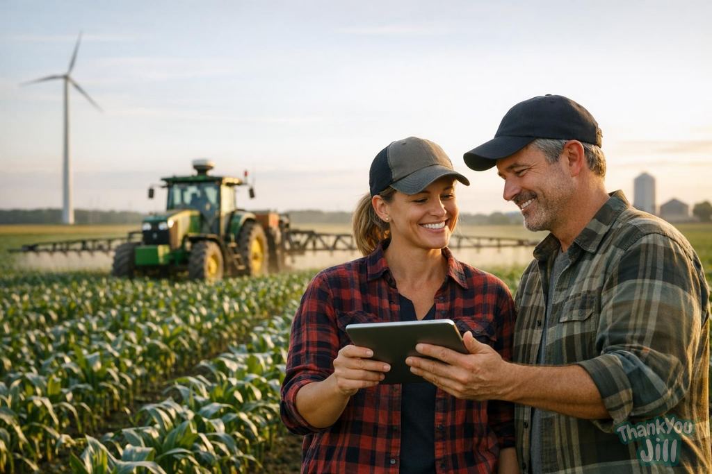
Precision farming (or precision agriculture) is an agronomic management approach that uses sensing technologies, data analysis, and variable rate application to optimize agricultural inputs (water, fertilizers, pesticides, seeds) based on the spatial variability of the field. The basic idea is simple but revolutionary compared to traditional agriculture: instead of treating a 10-hectare field as a uniform whole (the same amount of fertilizer per square meter), each zone of the field is treated differently based on its specific characteristics (soil type, moisture, vegetation density, local pest infestation).
The main technologies of precision farming
Soil and field sensors: wireless sensor networks that measure in real time soil moisture at various depths, temperature, pH, and electrical conductivity (correlated to soil texture and nutrient content). Data is transmitted to the cloud and integrated into irrigation and fertilization planning. Multispectral satellite imagery: satellites like Sentinel-2 (free, European Space Agency) and Planet Labs produce images that include non-visible spectral bands (NIR, Red Edge, SWIR) from which vegetation indices such as NDVI (Normalized Difference Vegetation Index: indicates vegetation health and density), NDRE (water stress), and NDMI (leaf water content) are calculated. These indices precisely map the zones of the field where plants are stressed or in good health. Agricultural drones: multispectral and thermal cameras mounted on UAVs (drones) produce extremely high-resolution maps (2-5 cm per pixel) of vegetation. They enable early identification of fungal diseases, pest infestations, water stress, and nutrient deficiencies weeks before they become visible to the naked eye. GPS-equipped agricultural machinery with variable rate application: tractors with centimeter-level GPS guidance, variable rate spreaders and sprayers (VRA: Variable Rate Application) that automatically adjust the dose of fertilizer or pesticide meter by meter following the prescription maps generated by field data analysis.
Quantified benefits of precision farming
Agronomic research has documented the benefits of precision farming compared to the traditional uniform approach. Fertilizers: average reduction of 20-30% of nitrogen applied while maintaining or increasing yields (meta-analysis by Basso et al., 2016). Pesticides: reduction of 15-25% of phytosanitary treatments thanks to site-specific application only in infested zones (spot spraying) instead of uniform field treatment. Water: reduction of 30-50% in irrigation consumption with sensor-guided precision deficit irrigation based on soil moisture sensors. Yields: average increase of 5-15% in yields thanks to optimized nutrient and water stress management. Emissions: the reduction of nitrogen in precision farming reduces nitrous oxide (N2O, a potent greenhouse gas with a warming potential 265 times greater than CO2) emissions: one of the most significant contributions of precision farming to climate mitigation.
Precision farming in Italy: current state
The adoption of precision farming in Italy is growing but still limited compared to the USA, the Netherlands, and Germany. The current picture: advanced mechanization (centimeter-level GPS on tractors) is present in 15-20% of professional agricultural enterprises with fields above 50 hectares. Agricultural drones are widespread among specialized contractors: small farms rent them rather than buy them. The use of free satellite data (Sentinel-2) is accessible through platforms like Copernicus, Agricolus, and xFarm (Italian precision farming platforms). The main barrier to adoption in Italy is land fragmentation: the average Italian agricultural enterprise has less than 8 hectares (vs. 17 ha EU average, 170 ha USA average). With such small fields, the cost per hectare of precision farming technologies is difficult to amortize. Agricultural cooperatives and land reclamation consortia are developing shared services (drones, soil analysis, data platforms) that allow even small farms to access technologies at shared costs.

Precision farming is not a technological luxury for a few large American ranches: it is the necessary response to the challenge of feeding 10 billion people with less water, less chemicals, and less soil. Every liter of water and every gram of nitrogen we don't use is a real gain for the soil and for the climate. Technology is not the end: it is the means to smarter and more respectful agriculture.
Digital platforms for precision farming in Italy
Various Italian and international platforms offer precision farming services accessible to small farms as well. xFarm (Switzerland-Italy): integrated agricultural business management platform with satellite imagery, IoT sensors, digital field notebooks, and input management. Used by 100,000+ farmers in Europe. Free basic plan. Agricolus (Italian, Perugia): decision support platform for phytosanitary defense. Integrates weather data, pathogen epidemiological models, and satellite imagery to suggest optimal treatments. Used by winegrowers, olive growers, and vegetable farmers. Planet Farming (connected to Planet Labs satellites): access to high-resolution daily satellite imagery with automatic vegetation index analysis. For large farms. Trimble Agriculture / John Deere Operations Center: major agricultural machinery manufacturers offer platforms integrated with their GPS tractors. John Deere Operations Center is one of the most widely used in the world for automatic guidance and variable rate application. Climate FieldView (Bayer): a very popular precision farming platform in the USA, expanding in Europe. Integrates field, weather, and historical data for decision support.
Drones in agriculture: practical applications
Drones (UAVs, Unmanned Aerial Vehicles) have concrete and already commercial applications in Italian agriculture. Mapping and diagnosis: drones with multispectral cameras fly over the field at 60-120 m altitude, producing high-resolution NDVI maps in minutes. Agricultural drone mapping services (provided by specialized contractors) cost 30-80 euros per hectare. Phytosanitary treatments with drones: spraying drones (DJI Agras T30, XAG P100) apply pesticides and foliar fertilizers with centimeter precision. Reduction of spraying by 30-50% compared to traditional tractors. Limitation: reduced payload capacity (10-30 liters): suitable for spot treatments and for terrain difficult to reach by ground equipment (steep vineyards, orchards). Seeding and distribution: drones can distribute seed, granules, and granular fertilizers with precise mapping. Used for reseeding sparse areas and for distributing beneficial insects (pest antagonists) in organic farming. Phenological monitoring: periodic footage over time documents the vegetative cycle of crops, allowing optimization of operation schedules (pruning, harvesting).
Connectivity in agriculture: LoRaWAN and 5G for fields
Sensor networks in fields require connectivity that is not always available in rural areas of Italy. Connectivity technologies for agricultural IoT: LoRaWAN (Long Range Wide Area Network): long-range data transmission network (10-15 km) with very low energy consumption. Ideal for soil sensors that transmit small amounts of data every hour. Several agricultural cooperatives in northern Italy have installed LoRaWAN gateways to cover their areas. NB-IoT and LTE-M: 4G standards for IoT. Uses existing cellular networks. Depends on 4G coverage in rural areas (often limited). 5G in agriculture: the ultra-broadband spectrum of 5G will enable real-time transmission of high-resolution video from drones, video sensors for real-time crop monitoring, and precise autonomous guidance of agricultural machinery. The first 5G agriculture experiments (5G for Agriculture) are underway in Emilia-Romagna, Lombardy, and Puglia with PNRR funding. Satellite connectivity (Starlink, OneWeb): the advent of low-latency satellite connectivity is revolutionizing connectivity in remote rural areas. Starlink is already available in many rural areas of Italy at around 50 euros/month: it opens agricultural IoT to all farms, even in mountain areas.
Frequently asked questions
What are the main benefits of reducing agricultural inputs with precision farming?
Precision farming reduces fertilizers by 20-30%, pesticides by 15-25%, and water by 30-50%, while improving yields by 5-15% and decreasing greenhouse gas emissions such as nitrous oxide, contributing to more sustainable and efficient agriculture.
How do agricultural drones work in crop monitoring and treatment?
Agricultural drones use multispectral and thermal cameras to map vegetation at high resolution, identifying stress and disease early. They can also apply pesticides and fertilizers with centimeter precision, reducing spraying by 30-50% compared to traditional methods.
When is it worthwhile to adopt precision farming technologies in small agricultural enterprises?
Adoption is worthwhile if you access shared services such as drones and soil analysis through cooperatives or consortia, since the cost per hectare of technologies is high. These models allow even small farms to benefit from precision farming without high direct investments.
Which connectivity technologies are best suited to support IoT sensors in precision farming?
LoRaWAN is ideal for low-power, long-distance sensors, while NB-IoT and LTE-M leverage existing 4G cellular networks. 5G offers real-time transmission for video and autonomous guidance, and satellite connectivity like Starlink extends access to remote rural areas.
Latest News




Comments
No comments yet. Be the first!
Leave a comment